
About 92 Energy Ltd
92 Energy Ltd. (ASX: 92E) is an ASX-listed uranium exploration company focused on targeting high-grade uranium deposits in the Athabasca Basin in northern Saskatchewan. The Athabasca Basin is renowned for hosting the highest-grade uranium deposits globally. 92 Energy wholly owns a portfolio of 10 exploration properties (Figure 1) covering a total area of 98,468 ha, including the Gemini Project, which hosts the Gemini Mineralized Zone (“GMZ”). The Company is strategically positioned for significant opportunities in discovering and developing uranium resources in the world-class Athabasca Basin.

92 Energy Athabasca Basin Projects
Gemini Project
The Gemini property consists of 21 mineral claims totalling 53,212 ha on the eastern margin of the Athabasca basin, straddling the basin boundary (Figure 2).

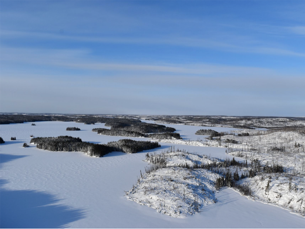
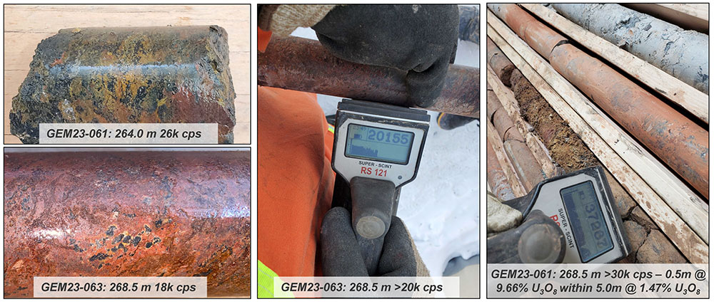
The Gemini project is located on the southeast margin of the Athabasca basin, approximately 42 km southeast of the McArthur River mine, and is host to the Gemini Mineralized Zone (“GMZ”). The GMZ was discovered during 92 Energy’s inaugural drilling campaign in 2021 on the fourth and final drill hole of the program. To date, 92 Energy has successfully completed 21,630m of diamond drilling in 76 drill holes spanning five drilling campaigns at the Gemini Project. The mineralized zone has been delineated over an area measuring 250 meters by 290 meters. Drilling at the GMZ has consistently encountered thick intervals of uranium mineralization, with some of the highlights including 43.0 m of 0.62% U3O8, featuring subintervals of 6.0 m at 2.17% and 18m at 1.16% U3O8 in drill hole GEM22-025, and 1.5 m of 4.69% U3O8 with a sub-interval of 0.5 m at 9.66% U3O8 in GEM23-061. The mineralization at the GMZ starts at a vertical depth of 60m from the surface and is classified as a basement-hosted unconformity-type uranium deposit (Figure 3).


Tower Project
The Tower Property consists of 2 mineral claims covering a total area of 6,301 ha within the eastern part of the Athabasca Basin, approximately 11 km southeast of Cameco’s Cigar Lake uranium mine (Figure 5).
In the fall of 2022, 92 Energy conducted a small diamond drill program to follow up on geophysical targets identified in a geophysical program completed in 2021. The drill program consisted of four drillholes totalling 1,919 m. Results from the drilling program identified anomalous uranium up to 570ppm U3O8 along with elevated concentrations of unconformity-associated uranium pathfinder elements, including arsenic, boron, cobalt, lead, and nickel. The depth to unconformity on the property ranges from 150 – 400 m.
Clay spectral analysis of drill core samples also identified dravite in the sandstone. Dravite is commonly found associated with uranium deposits in the Athabasca Basin, including the McArthur River uranium mine and the Arrow deposit.
The Tower Property is strategically located and boasts the potential for large, high-grade, unconformity-hosted uranium mineralization.

Clover Project
The Clover Project consists of five mineral claims with a total area of 10,985 ha within the eastern part of the Athabasca Basin, located between the Cigar Lake uranium mine approximately 27km to the east and the McArthur River uranium mine 21km to the south (Figure 6). The Clover property sits on trend 11 km west of the Close Lake property, which hosts the Tucker Lake (2.11% U3O8 over 22.3m) and Dolmen Lake (3.45% U3O8 over 7m) mineralized zones. Multiple conductors have been outlined, and one drill hole completed in 2007 intersected faulting in the sandstone as well as graphite in the basement. No follow-up holes have been completed since.
During the spring of 2023, 92 Energy conducted a ground electromagnetic survey, which identified a broad conductive zone over what is interpreted to be the intersection of two major structural trends, a northwest-trending and a northeast-trending magnetic lows. Three parallel conductor axes have been interpreted within the conductive zone, exhibiting a general trend towards the northeast, aligning with the Cigar Lake – Close Lake conductor trend observed on the Clover Property.
The observed strength of the EM responses and their close spatial association with the intersection of two structural trends make these targets a high priority for follow-up drilling.

Powerline Project
The Powerline property consists of 18 mineral claims with a total area of 7,884 ha and is centrally located about 500m from Uranium City. There are 12 past-producing uranium mines within a 10km radius of the property, with the Cayzor uranium mine situated within the property boundaries (Figure 7). The Powerline Property overlays two major faults, the St. Louis Fault and the Black Bay Fault, which are responsible for a significant amount of uranium production during the late 1940s and into the 1950s. An extensive amount of work has been conducted in the area, mostly during the 1940s and 1950s, with drilling highlights along the Black Bay Fault of 8.8 m of 0.2% U3O8 and 8.8 m of 0.12% U3O8 from 61.8 m and 42 m depth respectively as well as 11.2 m of 0.20% U3O8 from 79.2 m depth. Other notable highlights include 0.3m of 0.52% U3O8 and 0.61m of 0.63% U3O8 within a larger interval of 3.7m of 0.15% U3O8 from 8.2m depth.
The Powerline Property has been largely unexplored since the mid to late 1900s and presents a unique opportunity to apply modern exploration techniques and models to further the exploration on the property.

Wares Project
The Wares Property consists of 6 mineral claims with a total area of 4,686 ha within the northern part of the Athabasca Basin, approximately 60 km southeast of Uranium City and 30 km west of Fond du Lac (Figure 8). The property hosts the “Wares Uranium Occurrence”, where a historical drill hole intersected 0.18% U3O8 over 0.1 m at the unconformity at a depth of approximately 203m. Three additional drill holes nearby also intersected anomalous uranium concentrations up to 139 ppm. Within the northern part of the property, a prominent north-south magnetic low trend has been identified coincident with a conductive corridor consisting of multiple parallel conductors. Historical drilling within this trend encountered anomalous uranium values up to 197 ppm U at the unconformity associated with large illite halos in the overlying sandstone, a characteristic closely associated with large uranium deposits within the Athabasca Basin.
The Wares property has abundant historical geophysical coverage with multiple drill-ready targets.

Wormboiler Project
The Wormboiler Property consists of 1 mineral claim with a total area of 2,543 ha located on the northwestern margin of the Athabasca Basin approximately 30 km west of Black Lake and 25 km south of Stony Rapids. The property sits in a highly prospective corridor with major EM conductor trends associated with the Grease River and Black Lake faults running through the property. Anomalous uranium mineralization has been identified in four historical drill holes on the Wormboiler Property, with highlights including 4,550 ppm U over 0.5 m within bleached Athabasca sandstone just above the unconformity at a depth of 689.8m, as well as up to 1,810 ppm U below the unconformity within a strongly hematized zone. In addition to the anomalous uranium, dravite has also been noted within a zone of significant structural disruption.
The Wormboiler property shows promising results for follow-up work.
Cable Project
The Cable Property consists of 1 mineral claim covering an area of 1,380 ha in the south-central Athabasca Basin, approximately 75 kilometres west of Cameco’s Key Lake uranium mill. The property rests within a prospective corridor of the southern Cable Bay Shear Zone. Multiple drillholes east of the property have intersected anomalous uranium concentrations up to 707ppm. Additionally, the property rests within a magnetic low domain with multiple fault zones mapped within the property boundary.
Murphy Project
The Murphy Property consists of 3 mineral claims covering a total area of 5,121 ha in the eastern Athabasca Basin, approximately 35km north of Cameco’s Cigar Lake uranium mine, 25km west of Orano’s Midwest Project, and 28km northwest of Points North Landing on Highway 905.
The property sits in a highly prospective corridor approximately 4 km southeast of the La Rocque Lake Trend, which hosts several high-grade uranium deposits, including the Hurricane and the La Rocque Lake deposits, and the Alligator showing. Additionally, two prominent EM conductor trends run to the northwest and southeast of the property. These conductor trends have been effectively drill-tested with anomalous uranium concentrations of up to 1,750 ppm U at the unconformity. REE enrichment was noted in multiple drillholes that also contained anomalous uranium intercepts.
Snowbird Project
The Snowbird Property consists of 1 mineral claim with a total area of 2,384 ha located approximately 27 km south of the Athabasca Basin boundary and 133 km southwest of Cameco’s Key Lake uranium mill. The property lies west of the prospective Virgin River shear zone, which hosts Cameco’s Centennial deposit and the South Dufferin uranium project. No historical drilling has taken place on the Snowbird property. Further geophysical coverage is necessary to identify potential targets.
To learn more about 92 Energy, please visit https://www.92energy.com/
To learn more about the activity in the Athabasca Basin area and to view the digital map, go to https://digigeodata.com/area/athabasca-basin/-basin/