About K9 Gold Corp
K9 Gold Corp has assembled a highly-experienced and dynamic team to explore its JB Lithium project in the James Bay region of Quebec and its Stony Lake Gold Project in central Newfoundland . The Company also owns a 100% interest in the Desert Eagle Vanadium-Uranium project located in the historic Henry Mountains Mining District in SE Utah.
Stony Lake Project:
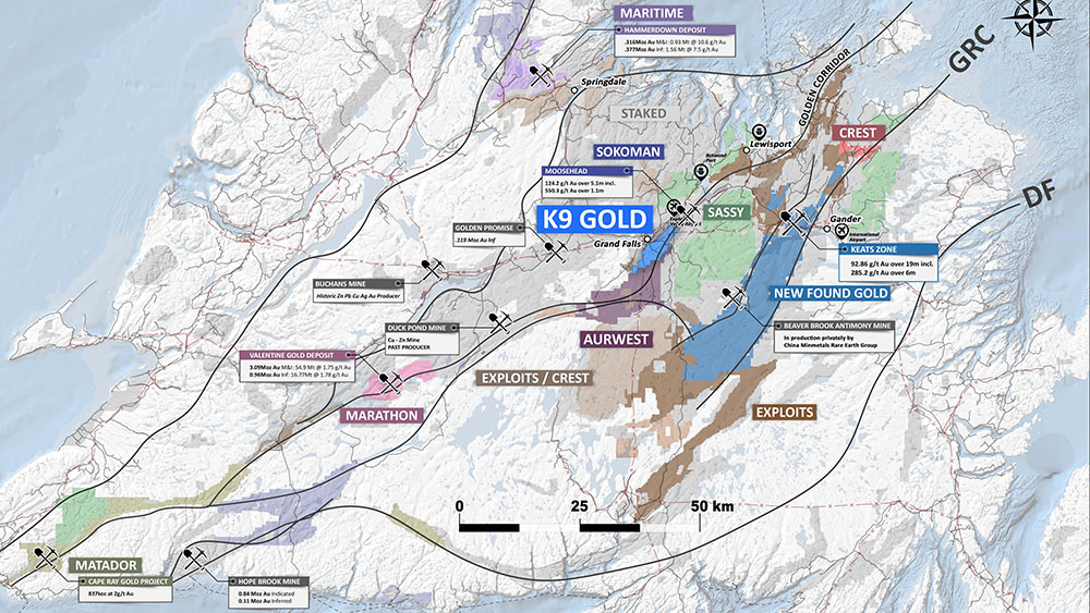
The project has been acquired from District Copper Corp by an option agreement, whereby K9 can earn up to a 100% interest in the project. Located within the Cape Ray/Valentine Lake structural trend in central Newfoundland, the Stony Lake Project comprises an area of 13,025 ha covering 27 km of favourable trend between Sokoman’s Moosehead discovery to the northeast and Marathon’s Valentine Lake mine to the southwest.
After extensive early stage exploration (airborne and ground geophysics, soil sampling, mapping and prospecting, K9 has completed 32 diamond drill holes on the property, for a total of 9,784 meters. Of this, 26 holes have been drilled on the Jumper’s Pond target with excellent results. Extensive gold mineralization has been encountered, with multiple very wide mineralized zones. These include 127.40 m averaging 0.61 g/t Au in JP21-022, 31.75 m averaging 1.52 g/t Au in JP22-029 and 27.35 m averaging 1.88 g/t Au in JP22-031.
The gold mineralization occurs within a broad deformation zone characterized by shearing and brecciation hosted in a sequence of intermediate to mafic volcanic rocks. Significant gold mineralization is interpreted to be concentrated along the axis of an anticlinal structure in the footwall of a major fault zone. The mineralization exhibits a strong spatial relationship to a positive chargeability anomaly. The mineralization remains open along strike and at depth.
Analytical results to date indicate a highly consistent pattern of gold distribution. This remarkable consistency of gold values encountered during the 2021 and 2022 drill campaigns is of particular importance in determining the true metal content of the Jumper’s Pond zone. Whereas with a high nugget effect the analytical results may not be indicative of the true metal content (either high or low), the results have significantly increased confidence in the reliability of the data.
The property also hosts multiple additional exploration targets, including the Moonlight zone, where drill hole ML21-016 intersected 9.52 m averaging 0.84 g/t Au. In the same area, soil samples from a shallow trench averaged 0.81 g/t Au over a width 15.0 meters.
Additional drilling is planned for the Jumper’s Pond zone in 2023.
JB Lithium Project:
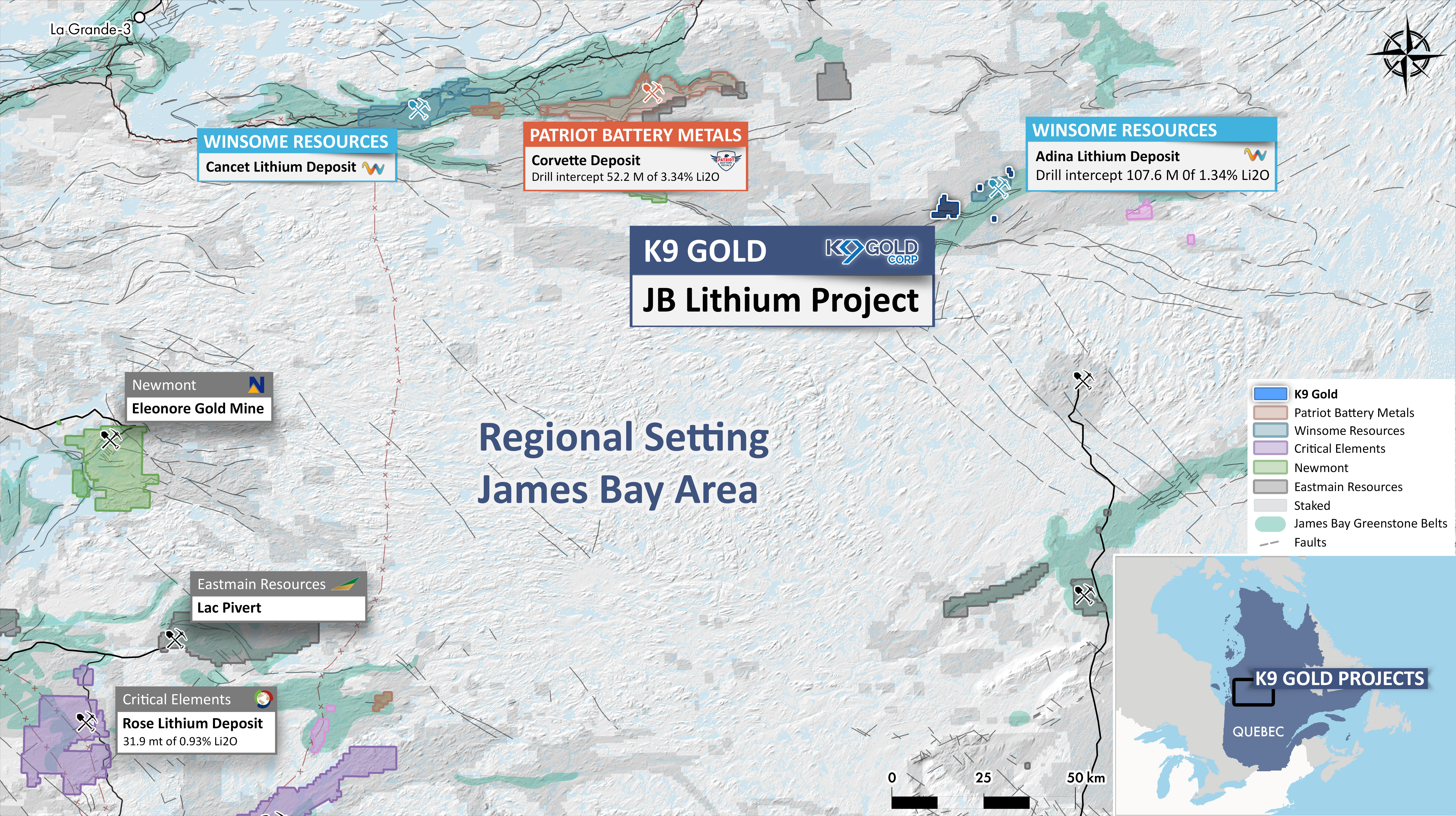
The JB Lithium project was acquired by a share purchase agreement with a numbered company, 1000175306 ONTARIO Ltd which hold an option agreement to acquire the property from 1Life Holdings Ltd. The property comprises 41 mining claims, totaling 2114 hectares. The property is located approximately 350 km south-southeast of Radisson, Quebec. Other projects in the area include Patriot Battery Metals Corvette project located 50 km to the west and Winsome Resources Lithium Adina project located approximately 5 km to the east. The James Bay property is underlain by a package of Archaean rocks that is similar to the geological setting of the corvette and Adina projects.
The JB Lithium Project is located in the La Grande sub-province of the Archaean Superior Province in Quebec. The Trieste Formation, which hosts lithium mineralization on the adjacent Adina property, transects the James Bay project area. Within the property boundaries, this Meso-Archaean age formation is mainly an ensemble of mylonites and banded amphibolites derived from basalt, which have been intruded by various intermediate rocks. A significant band of tonalite, part of the Meso-Archaean age Kamusaawach Intrusion, cuts through the centre of the property. Also cutting through the claims is a band of the Neo-Archaean Richardie Suite, an intrusive biotite-magnetite-hornblende granodiorite. The northern portion of the property is underlain by the Neo-Archaean Sauvolles Pluton, which is mainly of granitic composition. There is also a prominent Paleoproterozoic-age mafic dyke (Senneterre dyke system) cutting through the north of the property with a NE-SW orientation.
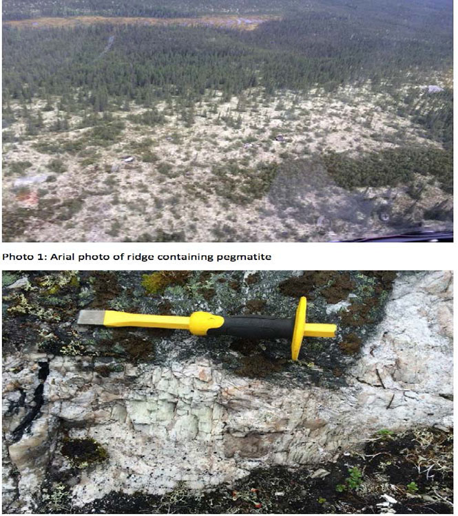
During a regional mapping program in 2013 by Government geologists, one outcrop was collected sample from the property, reported in the Quebec Government’s online geological database, SIGÉOM, an returned a value of 65 ppm Li. Several outcrops of tonalitic pegmatite were noted during the government mapping. In March 2023, K9 completed an airborne magnetometer and VLF survey of the property.
A summer 2023 exploration program is planned consisting initially of soil sampling, mapping and sampling.
Desert Eagle Project:
The area has seen extensive historic vanadium and uranium mining and is close to Anfield Energy Inc’s Shootaring Canyon mill.
The Desert Eagle Project is located in Garfield County, Utah and comprises 97 lode mining claims for a total of 2,004 acres (811 ha). The project is host to historic Vanadium and Uranium production beginning in the early 1900’s and continued erratically and intermittently to date. The project is located in the Trachyte Mining District situated to the east of the Henry Mountains, 95 miles south of Green River, Utah. Until recently practically all production from the Henry Mountains area came from the Trachyte Mining District.
Vanadium and Uranium mineralization on the Desert Eagle Project is confined to the Salt Wash member of the Jurassic Morrison formation. Historic development occurs across the entire project area with 31 historic mine adits and 21 prospect and prospect pits.
Primary vanadium mineralization occurs as carnotite-vanoxite type, with V:U ratios in excess of 5:1. Secondary copper mineralization occurs in some occurrences as bornite. Generally the mineralization is concentrated in carbonaceous material in sedimentary layers; however the mineralization also extends beyond this material and can occur in the surrounding sandstones. Depth to the mineralized zones varies from surface exposure to a maximum estimated depth of 180 ft. Overburden at a few of the surface operations consists of thin layers of windblown sand.
Weighted averages of seven channel samples (approx. 1.5 meters each) mainly from underground workings were 1.307% V2O5, and 0.245 U3O8.
To learn more about K9 Gold, go to https://www.k9goldcorp.com/
To learn more about the activity in the James Bay area and to view the digital map, go to https://digigeodata.com/area/james-bay/


