Map

Profile

Location Ontario, Canada
Commodities Primary Silver, Gold
Commodities Secondary Cobalt, Nickel, Copper
Total Current Year Production Period Ended December 31, 2019
Silver; ounces 0
Gold; ounces 0
Cobalt; pounds 0
Nickel; pounds 0
Copper; pounds 0
Total Known Current and Historical Production 1910 – 2019
Silver; ounces 71,831,000
Gold; ounces 38,000
Cobalt; pounds 1,403,000
Nickel; pounds 56,000
Copper; pounds 95,000
Total Known Compliant Reserves Proven & Probable
Silver; ounces 0
Gold; ounces 7,284,000
Cobalt; pounds 0
Nickel; pounds 0
Copper; pounds 0
Total Known Compliant Exclusive Resources Measured & Indicated
Silver; ounces 2,960,000
Gold; ounces 3,776,000
Cobalt; pounds 450,000
Nickel; pounds 15,966,000
Copper; pounds 8,095,000
Inferred
Silver; ounces 0
Gold; ounces 55,078,000
Cobalt; pounds 986,000
Nickel; pounds 220,089,000
Copper; pounds 11,826,000
Total Known Endowment 1909-2019
Silver; ounces 74,791,000
Gold; ounces 66,176,000
Cobalt; pounds 2,839,000
Nickel; pounds 236,111,000
Copper; pounds 20,016,000

Total Known Endowment includes current and historical production and compliant reserves and resources

Data compiled from DigiGeoData database,Ontario Mineral Deposit Inventory, technical reports, and corporate websites
DigiGeoData has compiled this information using best practices and does not warrant the completeness or accuracy.
All data should be checked and verified before use

Click to go to the Map Interface

History

Exploration in the Shining Tree-Gowganda area was related to the discovery of silver in the Cobalt area in 1903. Prospectors began looking outward from the Cobalt area for other areas that may be home to silver in Nipissing Diabase.

SILVER

Gowganda Area

The Gowganda silver rush occurred from 1906 -1910. Early access into the area was limited due to a lack of roads. Silver was discovered on several properties in 1908 some of which eventually produced silver.

The top producing mines include:

DigiGeoData - Shining Tree History table

GOLD

The Shining Tree gold camp underwent an initial surge of development from 1912 to 1925, and then again from 1933 to 1939.

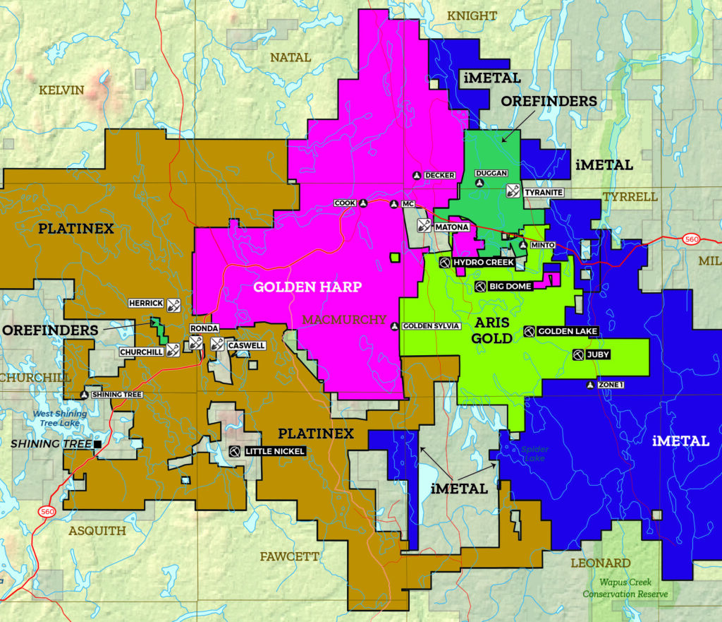
There are two main areas associated with gold exploration. The first centres around the Shining Tree area which is located centrally in the map area.

The second area is southwest of Gogama in the southwestern part of the map area.

Shining Tree Area

Gold was found in the Shining Tree area in 1912 on what is now the Rhonda Mine. The property produced a limited amount of gold (2727 ounces).

The Tyranite mine was discovered in 1939 and produced 31,352 ounces of gold until closure in 1942.

The Juby gold deposit is the only known gold deposit with NI 43-101 compliant resources. There are other zones which have not been fully explored.

Gogama Area

There has been no known gold production from this area.

Exploration in this area started in the early 1900s. The Cote and Watershed deposits are the only two deposits with NI 43-101 compliant resources.

With the increase in the price of gold and silver, exploitation continues in this area with companies seeking to increase the size of existing zones and deposits and even find new discoveries.

Geology

The Shining Tree – Gowganda area encompasses a region of Archean volcanic and sedimentary rocks that occurs south of the main part of the Abitibi greenstone belt. Volcano-sedimentary rocks of the Shining Tree – Gowganda area are intruded in the northwest by the Kenogamissi Batholith, intruded to the southwest by the Ramsey-Algoma granitoid complex, and are unconformably overlain to the east by sediments of the Huronian Supergroup.

Recent geochronological work has enabled the Archean stratigraphy of the area to be correlated with that of the rest of the Abitibi greenstone belt. In the area, Archean volcanic rocks consist of tholeiitic mafic’s, komatiitic ultramfic’s and calc-alkaline intermediate’s to felsic’s.

These volcanic rocks are part of the 2720-2710 Ma Kidd-Munro assemblage. The Indian Lake Group sediments were considered to belong to the Timiskaming assemblage as these sandstones and conglomerate rocks were similar in appearance to the Timiskaming assemblage rocks in the Timmins and Kirkland Lake areas. However, recent age dating of the Indian Lake Group sedimentary rocks on the property and in the Shining tree area has returned age determinations of 2690-2680 Ma which means that these rocks are at least 10 million years older than the 2676-2670 Ma Timiskaming assemblage rocks of the Timmins and Kirkland Lake areas. Therefore, the Indian Lake Group is most similar to the 2690-2680 Ma Porcupine assemblage.

In addition, the Ridout – Tyrrell Deformation Zone has been interpreted to extend through the Shining Tree (Ayer, et.al, 2013).

Adapted From:

11/21/2013 (D Guindon) – From Campbell, Sexton and Studd (2013)

Geology Ontario

Ministry of Energy, Northern Development and Mines

Resources

DigiGeoData - cobalt 600px

DigiGeoData - copper 600px

DigiGeoData - gold 600px

DigiGeoData - niquel 600px

DigiGeoData - silver 600px

Production

Sponsors