Map

Profile

Commodities Primary Gold, Silver, Copper,Molybdenum, Lead, Zinc
Commodities Secondary Nickel, Magnesite,Tungsten, Tin
Total Current Year Production Year Ended December 31, 2020
Gold, ounces 93,000
Silver; ounces 393,000
Copper; lbs 412,662,000
Molybdenum; lbs 3,300,000
Total Known Current and Historical Production 1875 – 2020
Gold, ounces 15,528,000
Silver; ounces 559,701,000
Copper; pounds 21,930,340,000
Molybdenum; pounds 428,822,000
Magnesite, tonnes 6,097,000
Lead; pounds 2,471,586,000
Zinc; pounds 21,240,371,000
Nickel; pounds 58,643,000
Cobalt; pounds 310,000
Tungsten; pounds 13,740,000
Tin; pounds 21,390,000
Total Known Compliant Reserves Proven & Probable
Gold, ounces 19,590,000
Silver; ounces 59,232,000
Copper; lbs 18,488,063,000
Molybdenum; lbs 70,460,000
Magnesite, tonnes 50,000,000
Total Known Compliant Exclusive Resources Measured & Indicated
Gold, ounces 7,969,000
Silver; ounces 42,712,000
Copper; pounds 15,757,989,000
Molybdenum; pounds 333,560,000
Magnesite, tonnes 13,986,000
Lead; pounds 454,439,000
Zinc; pounds 956,318,000
Tungsten; lbs 23,061,000
Inferred
Gold, ounces 4,842,000
Silver; ounces 22,356,000
Copper; pounds 4,743,094,000
Molybdenum; pounds 70,352,000
Magnesite, tonnes 284,000
Lead; pounds 752,179,000
Zinc; pounds 1,394,323,000
Nickel; pounds 72,197,000
Cobalt, pounds 3,800,000
Tungsten; lbs 33,037,000
Total Known Endowment 1909-2020
Gold, ounces 47,929,000
Silver; ounces 684,001,000
Copper; pounds 60,919,486,000
Molybdenum; pounds 903,194,000
Magnesium, pounds 70,367,000
Lead; pounds 3,678,204,000
Zinc; pounds 23,591,012,000
Nickel; pounds 130,840,000
Cobalt, pounds 4,110,000
Magnesite; pounds 70,367,000
Tin; lbs 21,390,000
Tungsten; lbs 69,838,000

Total Known Endowment includes current and historical production and compliant reserves and resources Data compiled from DigiGeoData database, British Columbia Minfile, technical reports, and corporate websites DigiGeoData has compiled this information using best practices and does not warrant the completeness or accuracy. All data should be checked and verified before use.

Click to go to the Map Interface

History

The DigiGeoData Southern British Columbia map area stretches across most of the southern part of the province and encompasses several established mining camps. The map covers a large area of over 202 thousand square kilometers. The area has a long exploration and mining history dating back to the late 1800s with close to 200 historic and currently operating mines and numerous deposits of various sizes and commodities. Some of the earliest staking in the western part of the map area began in 1896 around what is now the Bralorne mine. The staking occurred from placer miners looking for the source of gold in the rivers. The first production came from the Bralorne mine in 1900 which continued to produce until it closed in 1980. The same property hosted the Pioneer mine which produced from 1908 through 1983. The area around the Highland Valley mine has been actively explored since 1896 with the first mining starting in 1907. Exploration and mining in the area continued through the 1920s and then the area had limited exploration until the 1950s. The Bethlehem mine started production in 1963 and continued for close to 20 years The Lornex mine was next to begin production in 1972 and produced until it closed in 1986. The Highland Valley mine started production in 1983 and continues to be a significant producer of copper, molybdenum, and silver. Moving east towards Kamloops, exploration in the Afton area began in the mid-1800s as prospectors pushed their way into the interior of British Columbia following the Fraser and Caribou gold rushes. Mining started at the turn of the century through 1927 at several copper, gold, and silver mines including the Pothook, Iron King, Copper King, and Iron Mask. Although the property containing the New Afton Mine was staked in 1949, mining did not begin until 1977. The New Afton currently produces copper, silver, and gold. The Craigmont area, just north of Merritt, did not see significant exploration until the late 1950s. Production of copper began in 1961 and continued until the mine closed in 1982, adding iron to the production phase in the later years of operation. There has been a recent flurry of exploration in this area which is known as Spence’s Bridge. The third currently operating mine in Southern BC is located south of Princeton. Initial exploration around the Copper Mountain mine was reported as early as 1884. Initial unsuccessful production attempts were made between 1892 to 1922. Mining began again in 1937 and continued through 1957. Since then various periods of mining occurred with the current mine production commencing in mid-2011. The Greenwood mining camp is situated in the central-southern section of the province and straddles the United States border. It has undergone extensive exploration and development since the 1880s. The first gold ore was shipped from the Skylark vein in 1982. Gold mining on a small scale continued through the late 1990s through the late 1900s from several mines. The Phoenix mine was re-evaluated and mining re-started in 1959, continuing to 1976. Since then exploration and development have continued with several mines attempting gold production on a smaller scale. This area has recently seen a surge in exploration The Rossland mining camp is just southwest of Trail. It has a history of gold, silver, and copper production between 1894 and 1941. The southeastern part of the map area close to the Alberta border is host to 4 operating coal mines.

Geology

British Columbia has complex geology with mountainous physiography and a diversity of rock types and ages. Mountain ranges, including the Canadian Cordillera are the prominent physiographic feature in British Colombian terrain in general. The origin of Canadian Cordillera extends back some 750 million years to the episode of rifting that marked the first stages in the break-up and dispersal of “Rodinia”, a Neoproterozoic supercontinent. This breakup led to the opening of a new ocean basin that was the distant ancestor of the present Pacific Ocean basin and to the formation of a continent-ocean boundary that is preserved today within the eastern Canadian Cordillera. Metallogeny in British Columbia is closely linked to the tectonic evolution of the Canadian Cordillera, first as an accretionary orogen consisting of allochthonous terranes that were welded to and deformed with the western margin of ancestral North America, primarily during the Jurassic, and then as the site of post-accretionary tectonism and magmatism (e.g., Nelson et al., 2013). The Canadian Cordillera has been divided into five northwest-trending physiographic belts and the Southern BC map area includes parts of Coast, Intermontane, Omineca and Foreland physiographic belts.

DigiGeoData - image001
Figure: Simplified terrain map of the Canadian Cordillera (Gabrielse and Yorath, 1989; Wheeler et al. 1991

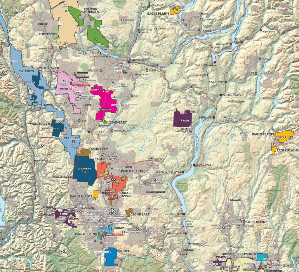
Coast Belt:  The main physiographic units in this belt are the Coast and Cascade mountains which are mainly formed by granitic rocks: (1) Jurassic through Cenozoic granitic rock; (2) remainder latest Proterozoic (?), Paleozoic to Holocene volcanic and sedimentary rocks formed mainly in magmatic arcs but locally in accretionary complexes, metamorphosed up to high grades and complexly deformed mainly in mid-Cretaceous through early Cenozoic time. Intermontane Belt: The key physiographic units in the belt includes the Interior, Stikine, and Yukon plateaus and Skeena Mountains formed by volcanic, sedimentary, and granitic rocks: (1) Devonian to Early Jurassic sedimentary and volcanic rocks formed in island arcs and chert-rich accretionary complexes; (2a) Middle Jurassic to early Cenozoic volcanic rocks formed mainly in continental arcs and (2b) marine and non-marine clastics eroded mainly from the uplifting Omineca Belt; (3) granitic rocks ranging in age from Devonian to Cenozoic; rocks deformed mainly by compression in Mesozoic and extension-transtension in early Cenozoic times. Omineca Belt: The Purcell, Selkirk, Monashee, Cariboo, Omineca, Cassiar and Selwyn mountains are the prominent physiographic units in this belt whereas sedimentary, volcanic and granitic rock, typically metamorphosed up to high grades are the main rock types: (1) local Paleoproterozoic continental crust; (2) Neoproterozoic rift related clastics and volcanics; (3) Paleozoic pericratonic, off-shelf clastic, and volcanic rocks; (4) local accreted late Paleozoic to Early Jurassic volcanic and sedimentary rocks formed in island arcs and marginal basins; (5) early Cenozoic continental volcanic and sedimentary rocks; (6) Paleozoic to early Tertiary granitic rocks; the rocks were complexly deformed mainly by compression between Middle Jurassic and early Tertiary time, and (in the south) by extension in early Tertiary time. Foreland Belt: This belt is in the most eastern part of the British Columbia terrain next to the Western Canadian Sedimentary Basin. The leading physiographic units in this belt includes the Rocky, Mackenzie, and Franklin mountains which are mainly formed by sedimentary rocks: (1) Mesoproterozoic (locally Paleoproterozoic) clastics, carbonates and minor magmatic rocks deposited in continental basins; (2) Neoproterozoic-earliest Cambrian shale, sandstone, conglomerate, minor carbonate and local mafic magmatic rock deposited during the rifting and initial breakup of the Rodinian supercontinent that created the ancient continental margin of western North America; (3) Cambrian to Jurassic shelf and slope, carbonate and shale deposited on and near the ancient continental margin of North America margin; (4) Late Jurassic to early Cenozoic marine to non-marine clastics eroded from the uplifting Omineca and Foreland belts; rocks folded and thrust eastwards over the ancient continental margin in Late Jurassic to early Tertiary time. Four main types of minerals deposits occur in the Southern BC map area: porphyry deposits, volcanogenic massive sulphides (VMS) deposits, vein deposits and skarn deposits. Metal deposits and mines found in this area include copper, molybdenum, gold, silver, lead, zinc, tungsten, magnesium and coal. Adapted from:

  • Monger, J. and Price R., 2002, THE CANADIAN CORDILLERA: Geology and Tectonic Evolution, CSEG Recorder, v. 17, pp 18-36
  • Prince, R.A., 1994, Cordilleran Tectonics and the Evolution of the Western Canada Sedimentary Basin, In Mossop, G.D. and Shetsen, I. (Ed) The Geological Atlas of the Western Canada Sedimentary Basin, Canadian Society of Petroleum Geologists/Alberta Research Council, pp.13-24
  • Provincial Overview of Exploration and Mining in British Columbia, 2019. British Columbia Ministry of Energy, Mines and Petroleum Resources, British Columbia Geological Survey Information Circular 2020-01, pp. 75-126

Resources

DigiGeoData - cobalt 600px

DigiGeoData - copper 600px

DigiGeoData - gold 600px

DigiGeoData - lead 600px

DigiGeoData - tcKDszTDBGHfeKQgb3H74o 320 80

DigiGeoData - molybdenum 600px

DigiGeoData - niquel 600px

DigiGeoData - silver 600px

DigiGeoData - tungsten 600px

DigiGeoData - zinc 600px

Production

Sponsors