Map

Profile

Location Nevada, United States
Commodities Primary Gold, Silver
Commodities Secondary Copper, Molybdenum, Lithium, Vanadium, Tungsten, Iron, Fluoride, Gallium, Lead, Zinc
Total Current Year Production Period Ended December 31, 2019
Gold; ounces 4,868,071
Silver; ounces 6,282,466
Copper; pounds 143,717,958
Molbdenum; pounds 766,699
Total Known Current and Historical Production 1859 – 2019
Gold; ounces 240,349,000
Silver; ounces To be calculated
Copper; pounds To be calculated
Molbdenum; pounds To be calculated
Lead; pounds To be calculated
Zinc; pounds To be calculated
Total Known Compliant Reserves Proven & Probable
Gold; ounces 76,992,000
Silver; ounces 684,731,000
Copper; pounds 7,621,819,000
Molbdenum; pounds 1,857,196,000
Lithium; pounds 7,472,119,000
Iron; tonnes 20,700,000
Vanadium; lbs 0
Tungsten; lbs 0
Fluoride; tonnes 0
Gallium; lbs 0
Lead; pounds 0
Zinc; pounds 0
Total Known Compliant Exclusive Resources Measured & Indicated
Gold; ounces 89,056,000
Silver; ounces 531,205,000
Copper; pounds 18,145,490,000
Molbdenum; pounds 992,058,000
Lithium; pounds 9,816,000
Iron; tonnes 37,655,000
Vanadium; lbs 527,000,000
Tungsten; lbs 52,166,000
Fluoride; tonnes 659,000
Gallium; lbs 1,574,000
Lead; pounds 0
Zinc; pounds 0
Inferred
Gold; ounces 42,694,000
Silver; ounces 401,822,000
Copper; pounds 8,749,420,000
Molbdenum; pounds 380,808,000
Lithium; pounds 32,001,603,000
Iron; tonnes 9,364,000
Vanadium; lbs 227,994,000
Tungsten; lbs 39,126,000
Fluoride; tonnes 8,592,000
Gallium; lbs 738,000
Lead; pounds 76,943,000
Zinc; pounds 588,889,000
Magnesium; pounds 111,000,000,000
Total Known Endowment 1859-2019
Gold; ounces 449,091,000
Silver; ounces To be calculated
Copper; pounds To be calculated
Molbdenum; pounds To be calculated
Lithium; pounds 39,483,538,000
Iron; tonnes 67,719,000
Vanadium; lbs 754,994,000
Tungsten; lbs 91,292,000
Fluoride; tonnes 9,251,000
Gallium; lbs 2,312,000
Lead; pounds To be calculated
Zinc; pounds To be calculated
Magnesium; pounds

*Total Known Endowment includes current and historical production and compliant reserves and resources. Data compiled from DigiGeoData database,Nevada Bureau of Mines, technical reports and corporate websites. DigiGeoData has compiled this information using best practices and does not warranty the completeness or accuracy. All data should be checked and verified before use.

Click to go to the Map Interface

History

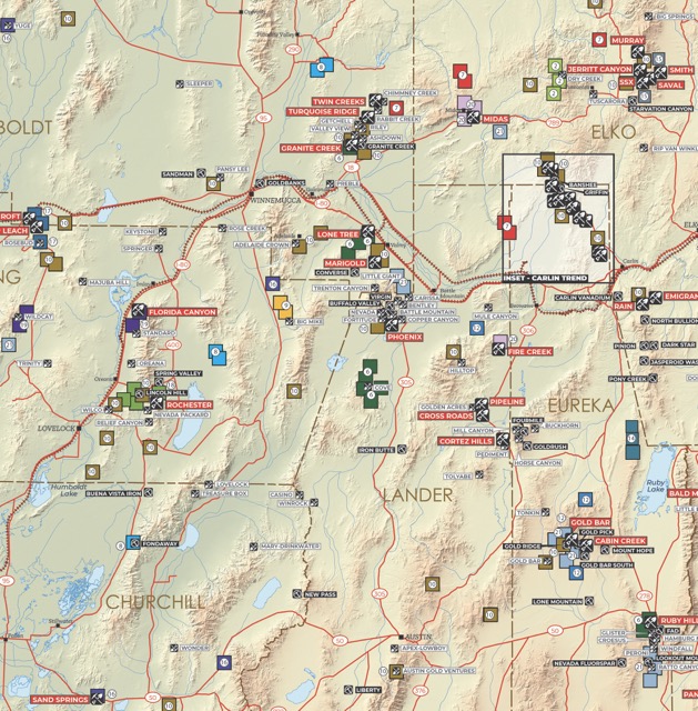
Modern mining began in Nevada in 1849 with the discovery of placer gold in a little stream flowing into the Carson River near the present town of Dayton. This discovery, made by Mormon ‘49ers on their way to the California gold fields, led others upstream into what was later known as the Virginia Range to find the outcroppings of the Comstock Lode in 1859. Nevada mining activity throughout the 143-year time span between 1849 and 1992 falls into four major periods.  Most of Nevada’s mining districts were discovered during the first two, the Comstock boom and the Tonopah – Goldfield boom.  These booms began with a major discovery, the Comstock in 1859, Tonopah in 1900, and Goldfield in 1902, each of which then set off a flurry of discoveries of less magnitude in nearby areas.  In the Comstock boom, silver City and Eureka areas were also discovered, with the Comstock lode producing the bulk of the gold and silver.  In the Tonopah – Goldfield boom other discoveries were made at Manhattan, Round Mountain, Fairview and Rochester.  Both discovery eras peaked within 5 to 10 years and both were over within 20 years of the first discovery. The third mining period, much smaller than the first two, was a depression-era boom set off by an increase in the price of gold in 1933.  Important gold discoveries made during this time, however, included the Standard mine in Pershing County, the Getchell mine in Humboldt County, the Northumberland mine in Nye County, and the Gold Acres mine in Lander County.  These were all occurrences of “invisible gold” and were the first to be found and mined in the state of what later was to be called the Carlin type deposit. W.O. Vanderburg, a mining engineer with the U.S. Bureau of Mines who was working in Nevada at that time, observed that this type of deposit would have been passed over by the early prospectors who depended largely on panning; the gold was too fine grained to be seen and would not concentrate in a gold pan.  Vanderburg predicted that similar deposits remained to be discovered in other areas of the state.  The significance of his remarks, however, was not recognized at this time. The last period, the Carlin boom, began with the discovery of the Carlin gold deposit in 1962.  This period and the previous depression-era period are measured by discoveries of individual deposits rather than entire mining districts and, for the most part, the discoveries have been made in old, established districts.  Most of these new deposits, however, are large enough alone to match production and reserves with the entire production of many of the historic districts. The Carlin discovery was one of the most significant events of this time and may be second only to the discovery of the Comstock in importance to Nevada mining.  The occurrence of “invisible gold”, so named because of tis very small grain size, in a large, bulk mineable deposit caught industry’s attention and set in motion Nevada’s third great prospecting rush.  A few gold deposits of this type, Standard, Getchell, Gold Acres, and Northumberland, had been found in the mini rush of the late 1930s but it took the discovery of Carlin to impress the industry with their significance. The Carlin trend is a belt extending northwest and southeast from the original discovery and is one of the major gold-producing regions of the world. The second of this new wave of invisible gold discoveries started with the discovery of Cortez deposit in Lander County in 1967.  Other discoveries followed in White Pine, Elko, Eureka, and Humboldt Counties. A current boom has been underway since 1981 and continues through to the present. Remarkably, 89% of Nevada’s gold production has been produced since the Carlin mine began production in 1965.  Approximately 87% has been produced from 1981 to the present and 24% has been produced in the last 10 years. Cumulative U.S. production, primarily since 1835, is approximately 602 million ounces or about 10.3% of total world gold production with Nevada accounting for 3.9% of cumulative world production.  Total gold production in Nevada to the end of 2017 was 229.9 million ounces. The Carlin trend alone accounts for 1.5% of all gold ever mined in the world.  At the end of 2017, cumulative production from the Carlin trend was 90.1 million ounces of gold, making it one of the most productive gold mining districts in the world. Text excerpts taken from: Muntean, J.L., Davis, D.A. and Ayling, B., The Nevada Mineral Industry 2017 (online version): Nevada Bureau of mines and Geology Special Publication MI-2017, 212p. Tingley, J.V., Horton, R.C., Lincoln, F.C., 1993, Outline of Nevada Mining History: Nevada Bureau of Mines and Geology Special Publication 15, 48p. DigiGeoData - Picture1 DigiGeoData - Picture2 DigiGeoData - Picture3 DigiGeoData - Picture4 Charts Citation: Muntean, J.L., Davis, D.A., and Ayling, B., 2018, The Nevada Mineral Industry 2017 [online version]: Nevada Bureau of Mines and Geology Special Publication MI-2017, 212 p

Geology

Cordilleran tectonics have created the Basin and Range landscape and interior drainage of the Great Basin, provided a rain shadow to make Nevada the nation’s driest state, and generated frequent earthquakes along normal and strike-slip faults. Nevada’s geologic fortunes make it the leading state in the production of gold, barite, diatomite, and mercury and currently the only state that produces magnesite, lithium, and the specialty clays, sepiolite and saponite. Nevada is also a major producer of geothermal power and gypsum.  The metals are primarily related to igneous activity, with major pluses of magma during the Jurassic, Cretaceous, and Tertiary.  Barite is mined from Paleozoic sedimentary rocks, and gypsum occurs in sedimentary beds of Permian, Triassic, Jurassic, and Tertiary age.  Lithium is extracted from brine beneath an unusual playa. Geothermal power production primarily occurs along Quaternary faults.  Other significant metals include silver, copper, lead, zinc and molybdenum. Mountain ranges in Nevada, commonly about 10 miles wide and rarely longer than 80 miles, are separated by valleys.  The geologic structure that controls this basin-and-range topography is dominated by faults.  Nearly every mountain range is bounded on at least one side by a fault that has been active, with large earthquakes, during the last 1.6 million years.  For the last several million years, these faults have raised and occasionally tilted the mountains and lowered the basins.  Over the years, these basins have filled with sediments that are derived from erosion of the mountains and that are locally tens of thousands of feet thick. Many of the range-bounding faults are still active.  Nevada is the third most seismically active state in the nation (behind California and Alaska), over the last 150 years, a magnitude 7 or greater earthquake has occurred somewhere in Nevada about once every 30 years.  Most faults are normal, although some are strike-slip faults.  The most apparent zone of strike-slip faults in Nevada is in a 50-mile wide swath along the northwest-trending border with California, the Walker Lane.  These northwest-trending faults are accommodating part of the motion between the Pacific Plate, which is moving relatively northwest, and the North American plate, which is moving relatively southeast.  The San Andreas Fault takes up most of the motion between these two plates. The generally north-south trend of mountain ranges in most of Nevada transforms into northwest-trending ranges within the Walker Lane. A western continental margin, similar to the Atlantic coast of today, persisted for hundreds of millions of years before the more active Pacific coast margin of today began to take shape about 360 million years ago.  Repeated and prolonged periods of interactions between the North American Plate and oceanic plates, expressed in folds, thrust fault, strike-slip faults, normal faults, igneous intrusions, volcanism, metamorphism, and sedimentary basins, are recorded in the rocks.  Some of the oldest rocks in Nevada occur near Las Vegas and the same great unconformity that separates the Paleozoic from the Precambrian at the base of the Grand Canyon is exposed at the foot of Frenchman Mountain, just east of Las Vegas.  Evidence for major Mesozoic thrusting is easily seen in the Spring Mountains west of Las Vegas. Nevada rocks document volcanic and intrusive igneous activity intermittently and repeatedly from earliest geologic history to within the last few thousand years.  Nevada’s igneous rocks are connected to seafloor spreading about 450 million years ago (much like the Mid-Atlantic Ridge or the East Pacific Rise today), collisions of ancient and modern plates, and hot spots in the Earth’s mantle and perhaps outer core (some Nevada volcanic rocks can be correlated with the Yellowstone hot spot, which, as a result of plate tectonics, was once underneath and produced volcanoes in southern Idaho and northern Nevada). Some of the volcanic rocks in western Nevada represent the precursor of the Cascade Range, and significant intrusions about 40, 100, and 160 million years ago are probably linked to similar plate tectonic settings, whereby oceanic plates were subducted beneath western North America. Most, but not all, ore deposits in Nevada are associated with igneous activity.  In some cases, metals came from the magmas themselves, and in other cases, the magmas provided heat for circulation of hot water that deposited metals in veins and fractured sedimentary rocks.  Some spectacular mineral specimens occur in ore deposits that formed when magmas intruded and metamorphosed sedimentary rocks. Much of the gold comes from a northwest-trending belt of gold deposits in northeastern Nevada known as the Carlin trend.  One of the interesting features of the Carlin trend is that nearly all of the gold is contained in microscopic particles with Paleozoic sedimentary rocks.  Although the sedimentary hosts for the gold are more than 250 million years old, the actual mineralization may have occurred much later (approximately 40 million ears ago) in association with igneous activity.   Adapted from: Geology of Nevada Jonathan G. Price State Geologist ad Director Nevada Bureau of Mines and Geology Mail Stop 178 University o0f Nevada, Reno Reno, Nevada 89557-0088

Resources

(Selected resources for producing and sponsor companies only)

DigiGeoData - copper 600px

DigiGeoData - gold 600px

DigiGeoData - lead 600px

DigiGeoData - tcKDszTDBGHfeKQgb3H74o 320 80

DigiGeoData - molybdenum 600px

DigiGeoData - silver 600px

DigiGeoData - tungsten 600px

DigiGeoData - zinc 600px

Production

Sponsors